Super Typhoon Lawin Projected Path and Tracking 2016: Heading to Northern Philippines (Update)
Super Typhoon Lawin, aka Typhoon cyclone Haima, maintains its strength as it moves towards northern Philippines.
NEWS UPDATE 2 ISSUED AT 11:00 PM, 19 October 2016
SUPER TYPHOON “LAWIN” HAS MAINTAINED ITS STRENGTH AND IS EXPECTED TO MAKE LANDFALL OVER CAGAYAN AREA.
• Estimated rainfall amount is from moderate to heavy within the 800 km diameter of the Super Typhoon.
• It is expected to make landfall over Cagayan Area between late tonight (11:00 PM) to early morning (2:00 AM, Oct. 20) then will cross Apayao and Ilocos Norte.
• Possible to exit PAR tomorrow evening (Oct. 20).
• Sea travel is risky over the eastern seaboard of Southern Luzon and the northern and eastern seaboards of Samar.
TROPICAL CYCLONE WARNING SIGNAL
TCWS #5
Cagayan, Isabela, Kalinga, Apayao, Northern Abra and Ilocos Norte
TCWS #4
Rest of Abra, Ilocos Sur, Mt. Province, Ifugao and Calayan Group of Islands
TCWS #3
La Union, Benguet, Nueva Vizcaya, Quirino and Northern Aurora
TCWS #2
Batanes Group of Islands, Pangasinan, Rest of of Aurora, Tarlac, Nueva Ecija, Northern Zambales, and Northern Quezon including Polillo Islands
TCWS #1
Rest of Zambales, Bulacan, Bataan, Pampanga, Rizal, Rest of Quezon, Cavite, Laguna, Batangas, Camarines Norte, Camarines Sur, Catanduanes, Albay and Metro Manila
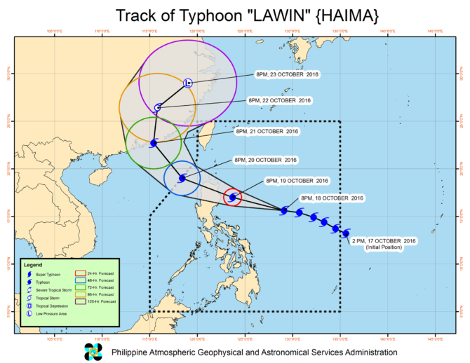
Location of eye/center At 10:00 PM today, the eye of Super Typhoon “LAWIN” was located based on all available data including Aparri Doppler radar at 95 km East of Tuguegarao City, Cagayan(17.5°N, 122.6°E).
Strength Maximum sustained winds of up to 225 kph near the center and gustiness of up to 315 kph.
Forecast Movement Forecast to move West Northwest at 25 kph.
Forecast Positions
• 24 Hour( Tomorrow evening): 330 km West Northwest of Laoag City, Ilocos Norte (OUTSIDE PAR)(19.5°N, 117.8°E)
• 48 Hour(Friday evening):805 km West Northwest of Basco, Batanes (OUTSIDE PAR)(23.2°N, 114.8°E)
• 72 Hour(Saturday evening): 995 km Northwest of Basco, Batanes (OUTSIDE PAR)(27.5°N, 116.0°E)
• 96 Hour(Sunday evening):990 km North of Basco, Batanes (OUTSIDE PAR)(29.3°N, 122.5°E)
The public and the disaster risk reduction and management council concerned are advised to take appropriate actions and watch for the next weather bulletin to be issued at 2 AM tomorrow.
Typhoon Lawin Projected Path and Tracking:

NEWS UPDATE 1 ISSUED AT 11:00 PM, 18 October 2016
(Valid for broadcast until the next bulletin to be issued at 5 AM tomorrow)
“LAWIN” HAS INTENSIFIED AS IT CONTINUES TO MOVE IN THE GENERAL DIRECTION OF NORTHERN LUZON.
•Estimated rainfall amount is from moderate to heavy within the 650 km diameter of the Typhoon.
•It is expected to intensify further before making landfall.
•It is expected to make landfall over Cagayan Area by Thursday early morning (Oct. 20) then will cross Apayao and Ilocos Norte.
•Possible to exit PAR on Friday early morning (Oct. 21).
•Sea travel is risky over the eastern seaboard of Southern Luzon and the northern and eastern seaboards of Samar.
Location of eye/center At 10:00 PM today, the eye of Typhoon “LAWIN” was located based on all available data at 755 km East of Baler, Aurora(15.7°N, 128.6°E).
Strength: Maximum sustained winds of up to 195 kph near the center and gustiness of up to 240 kph.
Forecast Movement: Forecast to move West Northwest at 25 kph.
Forecast Positions
• 24 Hour( Tomorrow evening): 190 km East Northeast of Casiguran, Aurora(17.0°N, 123.7°E)
•48 Hour(Thursday evening):250 km West Northwest of Laoag City, Ilocos Norte(19.0°N, 118.4°E)
•72 Hour(Friday evening): 725 km West Northwest of Basco, Batanes (OUTSIDE PAR)(22.7°N, 115.4°E)
•96 Hour(Saturday evening):915 km Northwest of Basco, Batanes (OUTSIDE PAR)(26.4°N, 115.8°E)
• 120 Hour(Sunday evening):1,000 km North Northwest of Basco, Batanes (OUTSIDE PAR)(29.0°N, 119.0°E)
TROPICAL CYCLONE WARNING SIGNAL
TCWS 2 (61-120 kph Expected in 24 hours)
Cagayan, Isabela and Northern Aurora
Impacts of the wind:
• Light to Moderate damage to high risk structures;
• Very light to light damage to medium-risk structures;
• No damage to very light damage to low risk structures
• Unshielded, old dilapidated schoolhouses, makeshift shanties, and other structures of light materials are partially damaged or unroofed.
• A number of nipa and cogon houses may be partially or totally unroofed.
• Some old galvanized iron (G.I.) roofs may be peeled or blown off.
• Some wooden, old electric posts are tilted or downed.
• Some damage to poorly constructed signs/billboards
• In general, the winds may bring light to moderate damage to the exposed communities. Most banana plants, a few mango trees, ipil-ipil and similar types of trees are downed or broken.
• Some coconut trees may be tilted with few others broken.
• Rice and corn may be adversely affected.
• Considerable damage to shrubbery and trees with some heavy-foliaged trees blown down.
Wave Height: (Open Sea) 4.1-14.0 meters Storm surge possible at coastal areas
TCWS 1 (30-60 kph Expected in 36 hours)
Calayan group of Islands, Batanes group of Islands2, Ilocos Norte, Ilocos Sur, Apayao, Abra, Kalinga, Mt. Province, Ifugao, La Union, Benguet, Tarlac, Nueva Vizcaya, Quirino, Pangasinan, Nueva Ecija, Rest of Aurora, Zambales, Pampanga, Bulacan, Northern Quezon including Polillo Islands, Camarines Norte, Camarines Sur and Catanduanes
Impacts of the wind
• Very light or no damage to low risk structures,
• Light damage to medium to high risk structures
• Slight damage to some houses of very light materials or makeshift structures in exposed communities. Some banana plants are tilted, a few downed and leaves are generally damaged
• Twigs of small trees may be broken.
• Rice crops, however, may suffer significant damage when it is in its flowering stage.
Wave Height: (Open Sea) 1.25-4.0 meters
The public and the disaster risk reduction and management council concerned are advised to take appropriate actions and watch for the next weather bulletin to be issued at 5 AM tomorrow.
Typhoon Lawin Projected Path and Tracking: