)
Typhoon Ferdie Projected Path and Tracking 2016: Maintains Strength Heading to Northern Philippine Islands (Update)
Typhoon Ferdie, aka Typhoon cyclone Carina, maintains its strength as it moves north of the Philippine islands.
Typhoon Ferdie Projected Path and Tracking:
Update 1: ISSUED AT 5:00 AM, 12 September 2016
(Valid for broadcast until the next bulletin to be issued at 11 AM today or earlier)
TYPHOON “FERDIE” HAS INTENSIFIED FURTHER WHILE MAINTAINING ITS WEST-NORTHWEST DIRECTION.
• Estimated rainfall amount is from moderate to heavy rains within its 300 km diameter of the typhoon.
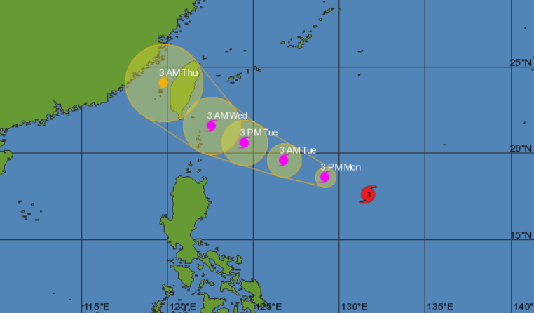
Location of eye/center: At 4:00 AM today, the eye of Typhoon “FERDIE” was located based on all available data at 1,015 km East of Tuguegarao City, Cagayan (17.7°N, 131.3°E).
Strength: Maximum sustained winds of up to 165 kph near the center and gustiness of up to 200 kph.
Forecast Movement: Forecast to move West Northwest at 22 kph.
Forecast Positions
• 24 Hour(Tomorrow morning): 550 km East Northeast of Aparri, Cagayan
• 48 Hour(Wednesday morning): 35 km Northwest of Itbayat, Batanes
• 72 Hour(Thursday morning): 600 km Northwest of Itbayat, Batanes (OUTSIDE PAR)
• 96 Hour(Friday morning): 945 km North Northwest of Itbayat, Batanes (OUTSIDE PAR)
Tropical Cyclone Warning Signal No. 1
(30-60 kph Expected in 36 hours)
Batanes and Babuyan Group of Islands
Impacts of the wind:
• Very light or no damage to low risk structures,
• Light damage to medium to high risk structures
• Slight damage to some houses of very light materials or makeshift structures in exposed communities. Some banana plants are tilted, a few downed and leaves are generally damaged
• Twigs of small trees may be broken.
• Rice crops, however, may suffer significant damage when it is in its flowering stage.
Wave Height: (Open Sea) 1.25-4.0 meters
The public and the disaster risk reduction and management council concerned are advised to take appropriate actions and watch for the next weather bulletin to be issued at 11 AM today or earlier.