)
Typhoon Carina Projected Path and Tracking 2016: Maintains Strength as it Hits Philippines (Update)
Typhoon Carina, aka Typhoon cyclone Carina, maintains its strength as it moves North Northwest towards eastern Luzon in the Philippines.
Typhoon Carina Projected Path and Tracking:
Update 1: ISSUED AT 5:00 PM, 29 JULY 2016
•Estimated rainfall amount is from moderate to heavy within the 300 km diameter of the Tropical Depression.
•Fisherfolk are alerted against moderate to rough seas over the eastern seaboards of Luzon and Visayas.
•Areas under TCWS #1, the rest of Visayas and the provinces of Albay, Sorsogon and Masbate are alerted against moderate to heavy rains which may trigger flashfloods and landslides.
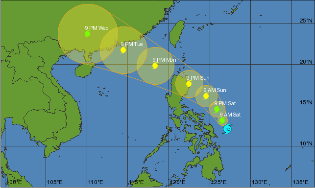
Location of eye/center: At 4:00 PM today, the center of Tropical Depression “CARINA”was estimated based on all available data at 135 km East Northeast of Borongan City, Eastern Samar(12.0°N, 126.6°E).
Strength: Maximum winds of 45 kph near the center.
Forecast Movement: Forecast to move North Northwest at 11 kph.
Forecast Positions:
•24 Hour(Tomorrow afternoon): 300 km East of Daet, Camarines Norte
•48 Hour(Sunday afternoon): 105 km East of Tuguegarao City
•72 Hour(Monday afternoon): 420 km West of Calayan, Cagayan(outside PAR)
•96 Hour(Tuesday afternoon): 725 km West of Itbayat,Batanes (outside PAR)
•120 Hour(Wednesday afternoon): 875 km West Northwest of Itbayat, Batanes.
TROPICAL CYCLONE WARNING SIGNAL 1 (30-60kph Expected in 36 hrs.)
Luzon – Catanduanes
Visayas – Northern Samar & Eastern Samar
Impacts of the Wind:
• Very light or no damage to low risk structures,
• Light damage to medium to high risk structures
• Slight damage to some houses of very light materials or makeshift structures in exposed communities. Some banana plants are tilted, a few downed and leaves are generally damaged
• Twigs of small trees may be broken.
• Rice crops, however, may suffer significant damage when it is in its flowering stage.
The public and the disaster risk reduction and management council concerned are advised to take appropriate actions and watch for the next weather bulletin to be issued at 11 PM today.