Typhoon Nonoy Projected Path and Tracking 2015: May Bring Heavy Rain in the Philippines (Update)
Typhoon Nonoy, aka Typhoon Melor, may bring heavy rain over parts of northern and eastern seaboard of Luzon and the eastern seaboard of Visayas in the Philippines.
Typhoon Nonoy Projected Path and Tracking:

Update 1: ISSUED AT 11:45 PM, 11 DECEMBER 2015
Location of center: At 11:00 PM today, the center of Tropical Storm “NONOYN” was estimated based on all available data at 1,250 km East of Maasin, Southern Leyte (10.0°N, 136.3°E).
Strength: Maximum sustained winds of 65 kph near the center and gustiness of up to 80 kph.
Forecast Movement: Forecast to move West Northwest at 25 kph.
Forecast Positions:
• 24 hour (Tomorrow evening): 910 km East of Masbate City, Masbate.
• 48 hour (Sunday evening): 345 km East Northeast of Virac Catanduanes
• 72 hour (Monday evening): 125 km Northeast of Virac Catanduanes.
• 96 hour (Tuesday evening): Vicinity of Quezon.
• 120 hour (Wednesday evening): 150 km West of Calapan City, Oriental Mindoro.
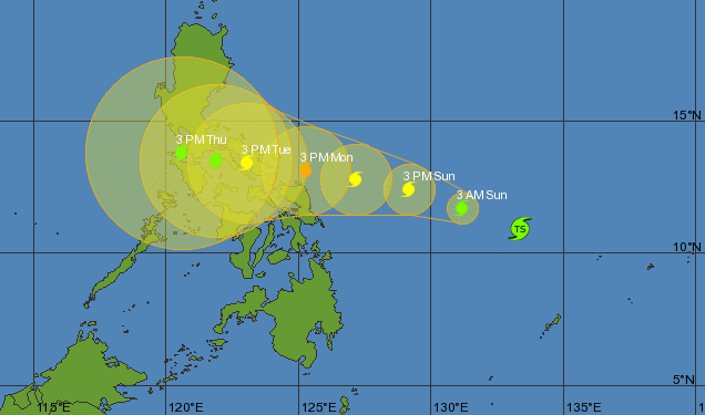
Update 2: ISSUED AT 11:00 AM, 12 DECEMBER 2015
Location of eye/center: At 10:00 AM today, the center of Tropical Storm “NONA” was estimated based on all available data at 1,025 km East of Maasin City, Southern Leyte (10.4°N, 134.2°E).
Strength: Maximum sustained winds of 65 kph near the center and gustiness of up to 80 kph.
Forecast Movement:Forecast to move West Northwest at 17 kph.
Forecast Positions: •24 hour (Tomorrow morning): 605 km East of Borongan City, Eastern Samar
•48 hour (Monday morning): 350 km East of Sorsogon City, Sorsogon
•72 hour (Tuesday morning): In the vicinity of Virac, Catanduanes
•96 hour (Wednesday morning): 55 km Northeast of Calapan City, Oriental Mindoro
•120 hour (Thusday morning): 195 km West of Calapan City
NO PUBLIC STORM WARNING SIGNAL
Typhoon Nonoy Projected Path and Tracking (Update 2):
Update 3: ISSUED AT 5:00 PM 12 December 2015
SYNOPSIS: at 4:00 pm today, the center of Tropical Storm “Nona” was estimated based on all available data at 795 km East of Guiuan, Eastern Samar (10.9°N, 133.0°E) with maximum sustained winds of 75 kph near the center and gustiness of up to 90 kph. It is forecast to move West Northwest at 19 kph. Northeast monsoon affecting Northern Luzon.
FORECAST: Cloudy skies with light to moderate rains and isolated thunderstorms will be experienced over the provinces of Surigao and Dinagat Island. Cloudy skies with light rains is expected over Batanes, Calayan and Babuyan Group of Islands. Partly cloudy to cloudy skies with isolated light rains is expected over Metro Manila and the rest of Luzon. Partly cloudy to cloudy skies with isolated rainshowers or thunderstorms will prevail over the rest of the country.
Moderate to strong winds blowing from the northeast will prevail over Extreme Northern Luzon and Eastern section of Luzon and Visayas and its coastal waters will be moderate to rough. Elsewhere, winds will be light to moderate coming from the northeast to north with slight to moderate seas.
Updated path and track:
