)
Hurricane Patricia Projected Path and Tracking as it Hits Mexico (UPDATES)
As previously reported, Hurricane Patricia is the “strongest hurricane on record” in the Atlantic and eastern North Pacific Basins. The category 5 hurricane will make landfall on Mexico’s Pacific coast between 6 p.m. and 10 p.m. ET Friday.
SEE ALSO: Strongest Hurricane Ever Recorded Hurricane Patricia to Hit Mexico
Up to 20 inches of rain was predicted for the Mexican states of Jalisco, Colima, Michoacan and Guerrero through Saturday, the U.S. National Hurricane Center said.
UPDATE 2 at 5 PM EDT on October 23, 2015
From NOAA: Extremely dangerous Hurricane Patricia is moving farther inland over southwestern Mexico. It’s centered as of 7 p.m. CDT about 135 miles southwest of Guadalajara, moving toward the north-northeast near 15 mph (24 km/h). This motion is expected to continue with some increase in forward speed tonight and Saturday. On the forecast track, the center of Patricia should continue to move inland over southwestern Mexico.
Satellite images indicate that Patricia has continued to weaken, and maximum sustained winds are estimated to be near 160 mph (260 km/h) with higher gusts. Patricia is a category 5 hurricane on the Saffir-Simpson Hurricane Wind Scale. Hurricane conditions are occurring across the hurricane warning area. Tropical storm conditions should continue to spread across portions of the warning area. Patricia is forecast to rapidly weaken over the mountains of Mexico and dissipate on Saturday.
Hurricane Patricia Projected Path and Tracking

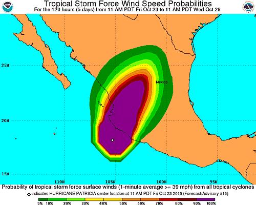
Hurricane Patricia Wind Speed
UPDATE 1 at 2:20 PM EDT on October 23, 2015
Hurricane Patricia Projected Path and Tracking

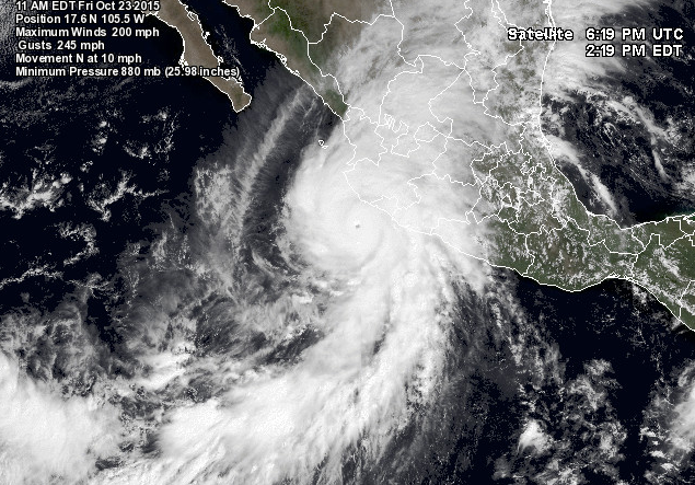
NASA’s Satellite image of Hurricane Patricia
Eye of Hurricane Patricia
