)
Typhoon Lando Projected Path and Tracking: May Bring Intense Rain in the Philippines (Update)
Typhoon Lando, aka Typhoon Koppu, could bring heavy rain over parts of northern and eastern seaboard of Luzon and the eastern seaboard of Visayas. Maximum sustained winds of 130 kph near the center and gustiness of up to 160 kph.
Typhoon Lando Projected Path and Tracking:
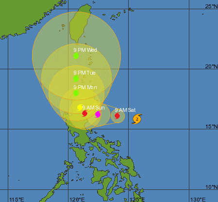
PAGASA Advisory: ISSUED AT 5:00 PM, 16 OCTOBER 2015
(Valid for broadcast until the next bulletin to be issued at 11 PM today)
TYPHOON “LANDO” MAINTAINED ITS STRENGTH AS IT MOVES CLOSER TO ISABELA-AURORA AREA.
• Estimated rainfall amount is from heavy to intense within the 600 km diameter of the typhoon.
• Fisherfolk are advised not to venture out over the northern and eastern seaboard of Luzon and the eastern seaboard of Visayas.
• Starting tomorrow, occasional rains and gusty winds will be experienced over provinces under PSWS #1 while those under PSWS #2 will have stormy weather.
Location of eye/center At 4:00 PM today, the center of Typhoon “LANDO” was located based on all available data at 510 km East of Baler, Aurora (15.6°N, 126.3°E).
Strength Maximum sustained winds of 130 kph near the center and gustiness of up to 160 kph.
Forecast Movement: Forecast to move West at 15 kph.
Forecast Positions
• 24 hour (Tomorrow afternoon): 135 km East of Baler, Aurora
• 48 hour (Sunday afternoon): 155 km South Southeast of Laoag City or in the vicinity of Hingyon, Ifugao
• 72 hour (Monday afternoon): 35 km East Southeast of Laoag City or in the vicinity of Nueva Era, Ilocos Norte
• 96 hour (Tuesday afternoon): 60 km West of Calayan, Cagayan
• 120 hour (Wednesday afternoon): 65 km West of Itbayat, Batanes
PUBLIC STORM WARNING SIGNAL
PSWS 2 (61-120kph Expected in 24 hrs.)
Aurora, Isabela, Quirino, Nueva Vizcaya, Nueva Ecija and Northern Quezon including Polillo Island
Impacts of the wind
• Light to Moderate damage to high risk structures;
• Very light to light damage to medium-risk structures;
• No damage to very light damage to low risk structures
• Unshielded, old dilapidated schoolhouses, makeshift shanties, and other structures of light materials are partially damaged or unroofed.
• A number of nipa and cogon houses may be partially or totally unroofed.
• Some old galvanized iron (G.I.) roofs may be peeled or blown off.
• Some wooden, old electric posts are tilted or downed.
• Some damage to poorly constructed signs/billboards
• In general, the winds may bring light to moderate damage to the exposed communities. Most banana plants, a few mango trees, ipil-ipil and similar types of trees are downed or broken
• Some coconut trees may be tilted with few others broken
• Rice and corn may be adversely affected
• Considerable damage to shrubbery and trees with some heavy-foliaged trees blown down.
Open Sea Wave Height: 4.1-14.0m
Storm surge possible at coastal areas
PSWS 1(30-60kph Expected in 36 hrs.)
Cagayan, Abra, Kalinga, Mt. Province, Ifugao, Benguet, Ilocos Sur, La Union, Pangasinan, Bulacan, Pampanga, Tarlac, Zambales, Bataan, Rizal, Laguna, rest of Quezon, Camarines Norte, Camarines Sur, Catanduanes and Metro Manila
Impacts of the wind
• Very light or no damage to low risk structures,
• Light damage to medium to high risk structures
• Slight damage to some houses of very light materials or makeshift structures in exposed communities. Some banana plants are tilted, a few downed and leaves are generally damaged
• Twigs of small trees may be broken.
• Rice crops, however, may suffer significant damage when it is in its flowering stage.
Open Sea Wave Height: 1.25-4.0 meters
The public and the disaster risk reduction and management council concerned are advised to take appropriate actions and watch for the next bulletin to be issued at 11 PM today.
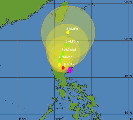
Update 2: ISSUED AT 5:00 AM, 18 OCTOBER 2015
(Valid for broadcast until the next bulletin to be issued at 11 AM today)
Typhoon “LANDO” has made landfall over Casiguran, Aurora and has remained almost stationary.
• Estimated rainfall amount is from heavy to intense within the 600 km diameter of the typhoon.
• Fisherfolk are advised not to venture out over the seaboards of Luzon, Visayas and the northern and eastern seaboard of Mindanao.
• Occasional rains and gusty winds will be experienced over provinces under PSWS #1 while those under PSWS #2, #3 and #4 will have stormy weather. Residents in low lying and mountainous areas of the provinces with PSWS are alerted against possible flashfloods and landslides.
• Storm surge may reach to a maximum of 3 – 4 meters in Aurora and neighboring provinces.
• Wave height in open sea may reach up to 14 meters or higher.
Location of eye/center: At 4:00 AM today, the eye of Typhoon “LANDO” was located based on all available data including Subic Doppler Radar in the vicinity of Casiguran Aurora (15.9°N, 121.8°E).
Strength: Maximum sustained winds of 175 kph near the center and gustiness of up to 210 kph.
Forecast Movement: Forecast to move West at 3 kph.
Forecast Positions
• 24 hour (Tomorrow morning): In the vicinity of Dupax del Sur, Nueva Vizcaya
• 48 hour (Tuesday morning): In the vicinity of Hungduan, Ifugao
• 72 hour (Wednesday morning): In the vicinity of Conner, Apayao
• 96 hour (Thursday morning): 60 km North of Aparri, Cagayan
• 120 hour (Friday morning): 50 km South Southeast of Basco, Batanes
____________________________________________________
Public Storm Warning Signal 04 (171-220 kph Expected in 12hrs.)
Aurora
• Very heavy damage to high-risk structures
• Heavy damage to medium-risk structures;
• Moderate damage to low-risk structures
• Considerable damage to structures of light materials (up to 75% are totally and partially destroyed); complete roof structure failures.
• Many houses of medium-built materials are unroofed, some with collapsed walls; extensive damage to doors and windows
• A few houses of first-class materials are partially damaged
• All signs/billboards are blown down. There is almost total damage to banana plantation,
• Most mango trees, ipil-ipil and similar types of large trees are downed or broken.
• Coconut plantation may suffer extensive damage.
• Rice and corn plantation may suffer severe losses.
____________________________________________________
Public Storm Warning Signal 03 (121-170 kph Expected in 18hrs.)
Isabela, Quirino, Nueva Vizcaya, Nueva Ecija, Ifugao and Northern Quezon including Polillo Islands
• Heavy damage to high-risk structures;
• Moderate damage to medium-risk structures;
• Light damage to low-risk structures
• Increasing damage (up to more than 50%) to old, dilapidated residential structures and houses of light materials. Majority of all nipa and cogon houses may be unroofed or destroyed
• Houses of medium strength materials (old, timber or mixed timber-CHB structures, usually with G.I. roofings); some warehouses or bodega-type structures are unroofed.
• There may be widespread disruption of electrical power and communication services.
• Almost all banana plants are downed
• Some big trees (acacia, mango, etc.) are broken or uprooted
• Dwarf-type or hybrid coconut trees are tilted or downed.
• Rice and corn crops may suffer heavy losses
• Damage to shrubbery & trees with foliage blown off; some large trees blown down.
____________________________________________________
Public Storm Warning Signal 02 (61-120kph Expected in 24 hrs.)
Cagayan including Calayan and Babuyan group of Islands, Benguet, Mt. Province, Kalinga, Apayao, Pangasinan, Tarlac, Pampanga, Bulacan, Rizal, rest of Quezon and Metro Manila
• Light to Moderate damage to high-risk structures;
• Very light to light damage to medium-risk structures;
• No damage to very light damage to low-risk structures
• Unshielded, old dilapidated schoolhouses, makeshift shanties, and other structures of light materials are partially damaged or unroofed.
• A number of nipa and cogon houses may be partially or totally unroofed.
• Some old galvanized iron (G.I.) roofs may be peeled or blown off.
• Some wooden, old electric posts are tilted or downed.
• Some damage to poorly constructed signs/billboards
• In general, the winds may bring light to moderate damage to the exposed communities. Most banana plants, a few mango trees, ipil-ipil and similar types of trees are downed or broken
• Some coconut trees may be tilted with few others broken
• Rice and corn may be adversely affected
• Considerable damage to shrubbery and trees with some heavy-foliaged trees blown down.
____________________________________________________
Public Storm Warning Signal 01 (30-60kph Expected in 36 hrs.)
Zambales, Ilocos Norte, Ilocos Sur, La Union, Abra, Camarines Norte, Bataan, Cavite, Laguna, Batangas and Batanes
• Very light or no damage to low-risk structures,
• Light damage to medium to high-risk structures
• Slight damage to some houses of very light materials or makeshift structures in exposed communities. Some banana plants are tilted, a few downed and leaves are generally damaged
• Twigs of small trees may be broken.
• Rice crops, however, may suffer significant damage when it is in its flowering stage.
• Public Storm Warning Signal (PSWS) elsewhere is now lowered.
• The public and the disaster risk reduction and management council concerned are advised to take appropriate actions and watch for the next bulletin to be issued at 11 AM today.
Update 3: ISSUED AT 11:00 AM, 19 OCTOBER 2015
Typhoon “LANDO” maintained its strength as it moves toward the provinces of Ilocos Norte, Abra and Apayao.
• Estimated rainfall amount is from heavy to intense within the 600 km diameter of the typhoon.
• Fisherfolk are advised not to venture out over the seaboards of Luzon and Visayas
• Occasional rains and gusty winds will be experienced over provinces under PSWS #1 while those under PSWS #2 will have stormy weather. Residents in low lying and mountainous areas of the provinces with PSWS are alerted against possible flashfloods and landslides.
• Storm surge may reach to a maximum of up to 2 meters in the provinces affected by the typhoon.
Location of eye/center: At 10:00 AM today, the center of Typhoon “LANDO” was located based on all available data at 20 km West of Vigan City, Ilocos Sur (17.6°N, 120.2°E).
Strength: Maximum sustained winds of 120 kph near the center and gustiness of up to 150 kph.
Forecast Movement: Forecast to move North Northeast at 5 kph.
Forecast Positions:
• 24 hour (Tomorrow morning): In the vicinity of Claveria, Cagayan
• 48 hour (Wednesday morning): 40 km North Northeast of Calayan, Cagayan
• 72 hour (Thursday morning): 20 km South of Itbayat, Batanes
• 96 hour (Friday morning): 135 km North of Itbayat, Batanes
120 hour (Saturday morning): 300 km North of Itbayat, Batanes
____________________________________________________
Public Storm Warning Signal 02 (61-120kph Expected in 24 hrs.)
Ilocos Norte, Ilocos Sur, La Union, Abra, Apayao, Kalinga, Mt. Province, Ifugao, Benguet and Cagayan including Calayan and Babuyan group of Islands
• Light to Moderate damage to high-risk structures;
• Very light to light damage to medium-risk structures;
• No damage to very light damage to low-risk structures
• Unshielded, old dilapidated schoolhouses, makeshift shanties, and other structures of light materials are partially damaged or unroofed.
• A number of nipa and cogon houses may be partially or totally unroofed.
• Some old galvanized iron (G.I.) roofs may be peeled or blown off.
• Some wooden, old electric posts are tilted or downed.
• Some damage to poorly constructed signs/billboards
• In general, the winds may bring light to moderate damage to the exposed communities. Most banana plants, a few mango trees, ipil-ipil and similar types of trees are downed or broken
• Some coconut trees may be tilted with few others broken
• Rice and corn may be adversely affected
• Considerable damage to shrubbery and trees with some heavy-foliaged trees blown down.
____________________________________________________
Public Storm Warning Signal 01 (30-60kph Expected in 36 hrs.)
Pangasinan, Zambales, Tarlac, Pampanga, Nueva Ecija, Nueva Vizcaya, Quirino, Aurora, Isabela and Batanes
• Very light or no damage to low-risk structures,
• Light damage to medium to high-risk structures
• Slight damage to some houses of very light materials or makeshift structures in exposed communities. Some banana plants are tilted, a few downed and leaves are generally damaged
• Twigs of small trees may be broken.
• Rice crops, however, may suffer significant damage when it is in its flowering stage.
Public Storm Warning Signal (PSWS) elsewhere is now lowered.
The public and the disaster risk reduction and management council concerned are advised to take appropriate actions and watch for the next bulletin to be issued at 5 PM today.