)
Typhoon Falcon Projected Path and Tracking: May Affect Northern Philippines (Update)
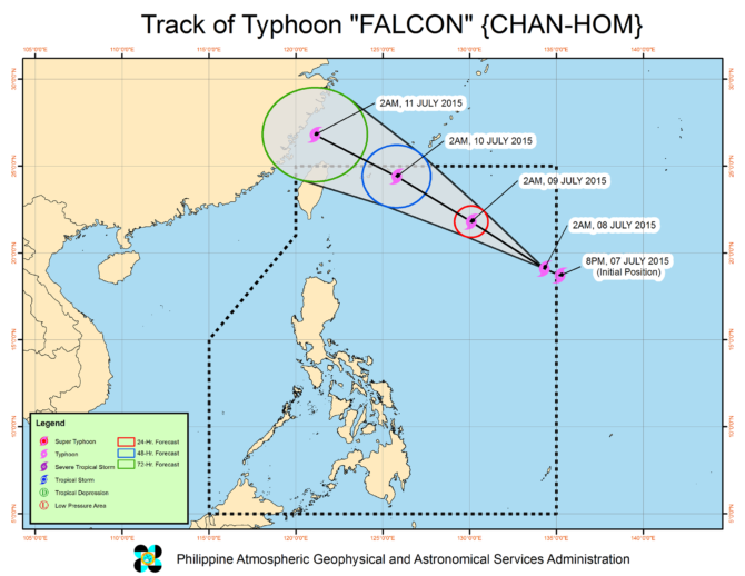
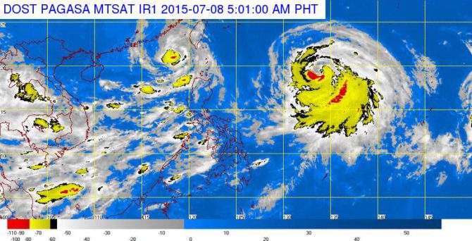
After Typhoon Egay, here comes the next one — Typhoon Falcon that may hit the Philippines. At 4:00 am today, 08 July 2015, the eye of Typhoon “#FalconPH” was located based on all available data at 1330 km East Northeast of Aparri, Cagayan or at 1335 km East of Calayan, Cagayan (19.3°N, 134.2°E) with maximum sustained winds of 130 kph near the center and gustiness of up to 160 kph. It is forecast to move west northwest at 20 kph. Southwest monsoon affecting Luzon.
FORECAST: Monsoon rains which may trigger flashfloods and landslides will be experienced over the provinces of Mindoro, Palawan, Zambales and Bataan. Light to moderate rains and thunderstorms will be experienced over Metro Manila, Mindoro, Palawan and Western Visayas. Partly cloudy to cloudy skies with isolated thunderstorms will prevail over the rest of the country.
Moderate to strong winds blowing from the southwest will prevail over the entire archipelago with moderate to rough seas.
Typhoon Falcon Projected Path and Tracking:
Satellite Image:
Update 1: at 11:00 PM, 09 JULY 2015
TYPHOON “FALCON” HAS SLIGHTLY INTENSIFIED AND IS ABOUT TO EXIT THE PHILIPPINE AREA OF RESPONSIBILITY (PAR)
• Estimated rainfall amount is from heavy to at times intense within the 300 km radius of the typhoon.
• Fisherfolk are advised not to venture out over the seaboards of Luzon and Visayas.
• Falcon will enhance the Southwest Monsoon and will bring moderate to occasionally heavy rains over Luzon and Visayas especially over the western sections.
• Residents in mountainous and low-lying areas are alerted against possible flashfloods and landslides.
• Typhoon Falcon is about to exit PAR tomorrow early morning.
Location of eye/center: At 10:00 PM today, the eye of Typhoon “FALCON” was located based on all available data at 695 km Northeast of Itbayat, Batanes (24.5°N, 127.3°E).
Strength: Maximum sustained winds of 150 kph near the center and gustiness of up to 185 kph.
Forecast Movement: Forecast to move Northwest at 22 kph.
Forecast Positions:
• 24 hour (Tomorrow evening): Outside the Philippine Area of Responsibility (PAR) or at 790 km North Northeast of Itbayat, Batanes
• 48 hour (Saturday evening): 1195 km North Northwest of Itbayat, Batanes (Outside PAR)
NO PUBLIC STORM WARNING SIGNAL