)
Typhoon Egay Projected Path and Tracking: May Hit Northern Philippines (Update)
Typhoon Egay Advisory issued at 11:00 AM, 03 JULY 2015.
TROPICAL STORM “EGAY” HAS MAINTAINED ITS STRENGTH AS IT MOVES CLOSER TO NORTHERN LUZON.
• Estimated rainfall amount is from moderate to heavy within the 400 km diameter of the tropical storm.
• Fisher folk and small sea crafts are advised not to venture out over the eastern seaboard of Central Luzon, seaboards of Southern Luzon and Visayas and the northern and eastern seaboards of Mindanao.
• Residents in low lying and mountainous areas of Bicol Region and Samar provinces are alerted against possible flashfloods and landslides.
Location of eye/center: At 10:00 AM today, the center of Tropical Storm “EGAY” was estimated based on all available data at 310 km Northeast of Virac, Catanduanes (15.6°N, 126.3°E).
Strength: Maximum sustained winds of 65 kph near the center and gustiness of up to 80 kph
Forecast Movement: Forecast to move Northwest at 13 kph.
Forecast Positions:
• 24 hour (Tomorrow morning): 260 km East of Tuguegarao City, Cagayan.
• 48 hour (Sunday morning): 145 km Northeast of Aparri, Cagayan
• 72 hour (Monday morning): Vicinity of Basco, Batanes.
• 96 hour (Tuesday morning): 160 km North Northwest of Basco, Batanes.
• 120 hour (Wednesday morning): 330 km North Northwest of Basco, Batanes.
Public Storm Warning Signal No. 1
(30-60 kph Expected in 36 hrs.)
Isabela and Cagayan including Calayan and Babuyan group of Islands.
Impacts of the wind:
• Very light or no damage to high risk structures,
• Light damage to medium to low risk structures
• Slight damage to some houses of very light materials or makeshift structures in exposed communities. Some banana plants are tilted, a few downed and leaves are generally damaged
• Twigs of small trees may be broken.
• Rice crops, however, may suffer significant damage when it is in its flowering stage.
Wave Height: (Open Sea) 1.25-4.0 meters
The public and the disaster risk reduction and management council concerned are advised to take appropriate actions and watch for the next bulletin to be issued at 5 PM today.
Path and Tracking Projection

Update 2: 5:00 AM, 04 JULY 2015
TROPICAL STORM “EGAY” HAS MAINTAINED ITS STRENGTH AS IT CONTINUES TO MOVE CLOSER TO NORTHERN LUZON.
• Estimated rainfall amount is from moderate to occasionally heavy within the 400 km diameter of the tropical storm.
• Fisher folk and small sea crafts are advised not to venture out over the seaboards of Southern Luzon and Visayas and the northern seaboard of Mindanao.
• Residents in low lying and mountainous areas Metro Manila, MIMAROPA, CALABARZON and Bicol Region are alerted against possible flashfloods and landslides.
Location of eye/center: At 4:00 AM today, the center of Tropical Storm “EGAY” was estimated based on Baler Doppler Radar and all available data at 380 km East of Baler, Aurora (15.7°N, 125.1°E).
Strength: Maximum sustained winds of 85 kph near the center and gustiness of up to 100 kph
Forecast Movement: Forecast to move West Northwest at 10 kph.
Forecast Positions:
• 24 hour (Tomorrow morning): 245 km East Northeast of Casiguran, Aurora.
• 48 hour (Monday morning): 40 km Northeast of Aparri, Cagayan.
• 72 hour (Tuesday morning): 30 km Southwest of Basco, Batanes.
• 96 hour (Wednesday morning): 150 km North of Basco, Batanes.
• 120 hour (Thursday morning): 545 km North Northeast of Basco, Batanes or out of the Philippine Area of Responsibility (PAR).
PUBLIC STORM WARNING SIGNAL
PSWS#2(61-120 kph Expected in 24 hrs.)
Luzon: Isabela, Quirino and Northern Aurora
Wave Height: (Open Sea) 4.1-14.0 meters
STORM SURGE possible at coastal areas
Impacts of the wind:
• Light to moderate damage to high-risk structures;
• Very light to light damage to medium-risk structures;
• No damage to very light damage to low-risk structures;
• Unshielded, old dilapidated schoolhouses, makeshift shanties, and other structures of light materials are partially damaged or unroofed.
• A number of nipa and cogon houses may be partially or totally unroofed.
• Some galvanized iron (G.I.) roofs may be peeled or blown off.
• Some wooden, old electric posts are tilted or downed.
• Some damage to poorly constructed signs/billboards.
• In general, the winds may bring light to moderate damage to the exposed communities. Most banana plants, a few mango trees, ipil-ipil and similar types of trees are downed or broken.
• Some coconut trees may be tilted with few others broken.
• Rice and corn may be adversely affected.
• Considerable damage to shrubbery and trees with some heavy-foliaged trees blown down.
PSWS#1(30-60 kph Expected in 36 hrs.)
Luzon: Rest of Aurora, Nueva Ecija, Nueva Vizcaya, Ifugao, Benguet, Mt. Province, Kalinga, Apayao, Abra, Ilocos Norte, Ilocos Sur, Cagayan including Babuyan and Calayan Group of Islands.
Wave Height: (Open Sea) 1.25-4.0 meters
Impacts of the wind:
• Very light or no damage to high risk structures,
• Light damage to medium to low risk structures
• Slight damage to some houses of very light materials or makeshift structures in exposed communities. Some banana plants are tilted, a few downed and leaves are generally damaged
• Twigs of small trees may be broken.
• Rice crops, however, may suffer significant damage when it is in its flowering stage.
The public and the disaster risk reduction and management council concerned are advised to take appropriate actions and watch for the next bulletin to be issued at 11AM today.
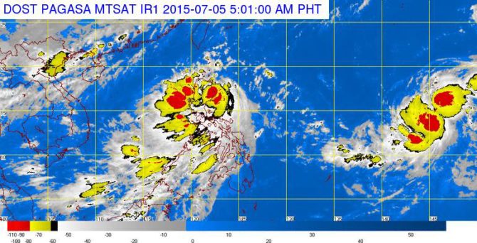
Update 3: As of 7AM today 05 July 2015, Severe Tropical Storm #EgayPH was estimated in the vicinity of Peñablanca, Cagayan (17.7°N, 122.1°E). Maximum winds/gust (95/120kph).
Update 4: At 11:00 PM, 06 JULY 2015
Location of eye/center: At 10:00 PM today, the center of Tropical Storm “EGAY” was estimated based on all available data at 225 km Northwest of Laoag City, Ilocos Norte (19.8°N, 119.3°E).
Strength: Maximum sustained winds of 75 kph near the center and gustiness of up to 90 kph
Forecast Movement: Forecast to move North at 7 kph.
Forecast Positions:
• 24 hour (Tomorrow evening): outside the Philippine Area of Responsibility (PAR) or at 275 km West Northwest of Basco, Batanes.
• 48 hour (Wednesday evening): 430 km Northwest of Basco, Batanes (outside PAR).
• 72 hour (Thursday evening): 615 km Northwest of Basco, Batanes (outside PAR).
Public Storm Warning Signal No. 1
(30-60kph Expected in 36 hrs.)
Ilocos Norte, Batanes, Calayan and Babuyan group of Islands, Northwest of Cagayan and Apayao.
Impacts of the wind:
• Very light or no damage to high risk structures,
• Light damage to medium to low risk structures
• Slight damage to some houses of very light materials or makeshift structures in exposed communities. Some banana plants are tilted, a few downed and leaves are generally damaged
• Twigs of small trees may be broken.
• Rice crops, however, may suffer significant damage when it is in its flowering stage.
Open Sea Wave Height: 1.25-4.0 meters
• Public storm warning signals elsewhere are now lifted.
• The public and the disaster risk reduction and management council concerned are advised to take appropriate actions and watch for the next bulletin to be issued at 5AM tomorrow.