Super Typhoon Dodong Path and Track 2015: Philippines Cyclone May Make Landfall
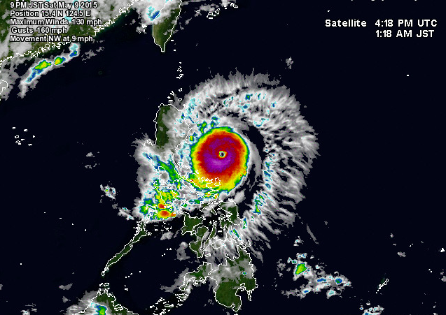
The Philippine Atmospheric, Geophysical and Astronomical Services Administration (Pagasa) said that Super Typhoon Dodong was located at 270 km East Northeast of Virac, Catanduanes (14.0°N,126.7°E).
At 4:00 am, today, the center of typhoon “DODONG” was located based on Virac doppler radar and all available data at 290 km East Northeast of Virac, Catanduanes (13.8?N, 126.9?E) with maximum winds of 160 kph near the center and gustiness of up to 195 kph. It is forecast to move West Northwest at 20 kph.
Stormy weather with rough to very rough seas will be experienced over Catanduanes, Polillo Island, Aurora, Quirino and Isabela while Cordillera, rest of Bicol Region, rest of Cagayan Valley, Northern Samar, Eastern Samar, Quezon and Nueva Ecija will have rains with gusty winds. Cloudy skies with light to moderate rains and thunderstorms will be experienced over Metro Manila, rest of Central Luzon , Cavite, Laguna, Batangas, Rizal, Mindoro, Marinduque, Romblon and rest of Visayas. The rest of the country will have partly cloudy to cloudy skies with isolated rainshowers or thunderstorms.
Update: 5:00 AM 09 May 2015
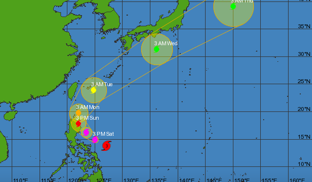
Typhoon Dodong Path and Track 2015 Forecast
Typhoon Dodong Satellite Image
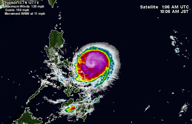
Update: 9:00 PM 09 May 2015. Typhoon ?#?DodongPH? was located at 320 km East Northeast of Infanta, Quezon (15.5°N,124.5°E).
Typhoon Dodong Path and Track 2015 Forecast

Typhoon Dodong Satellite Image