Super Typhoon Chedeng Path and Track 2015: Philippines Cyclone May Hit Islands This Holy Week
The Philippine Atmospheric, Geophysical and Astronomical Services Administration (Pagasa) said that Super Typhoon Chedeng (Tropical Storm Maysak) could enter the Philippine area of responsibility (PAR) by Wednesday evening or Thursday morning.
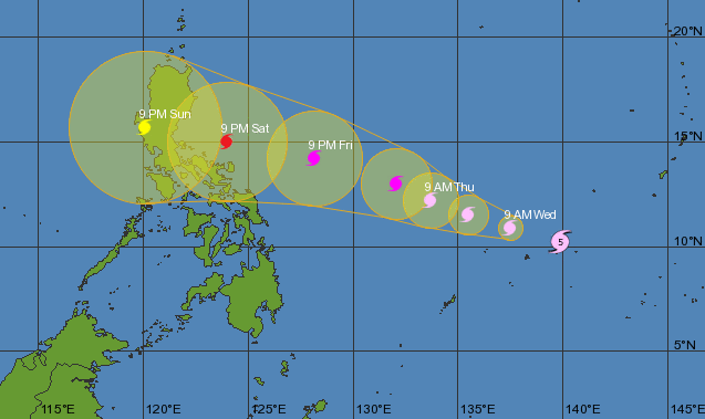
As of 10 a.m., state weather agency PAGASA said Chedeng has intensified further as it approaches the country. Typhoon Chedeng is packed with maximum winds of 175 kph and gustiness of 210 kph and is forecast to move west-northwest at 20 kph.
Typhoon Chedeng Path and Track 2015 Forecast
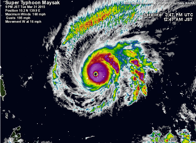
Typhoon Chedeng Satellite Image
Update 1: At 5:00 AM 01 April 2015
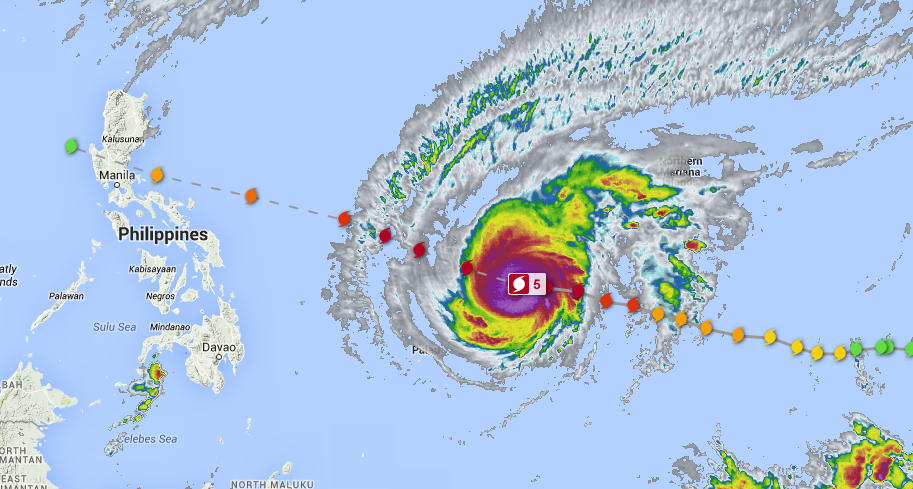
Ridge of High Pressure Area (HPA) extending over Northern Luzon. Meanwhile, at 4:00 am today, the eye of Typhoon “MAYSAK”(International Name) outside the Philippine Area of Responsibility (PAR) was located based on all available data at 1,410 km East of Surigao City (10.4?N, 138.4?E), with maximum sustained winds of 215 kph near the center and gustiness of up to 250 kph. It is forecast to move West Northwest at 17 kph.


Update 2: At 9PM 01 April 2015
Within the next 24 hours (around Thursday afternoon, April 2), PAGASA will raise Public Storm Warning Signal over Bicol and Samar provinces. Hence, sea travel over these areas will be possibly suspended. It is estimated to make landfall over the eastern coast of Aurora, Quezon or Isabela by late Saturday (April 4) or early Sunday (April 5).
Heavy to at times intense rainfall is expected within the 150-200km radius of the typhoon. The public is alerted against flashfloods over low-lying areas and landslides along mountain slopes particularly over Aurora-Quezon area. Storm surges and sea surface waves of up to 4 meters are possible over the eastern coasts of Samar, Bicol and Aurora-Quezon.
What to expect during Holy Week (April 1– 5, 2015)
• Wednesday – Friday (April 1-3):
– Eastern Luzon will experience good weather today and tomorrow but will have rains and gusty winds starting Friday (April 3).
– Basically good weather (warm and humid) with the possibility of isolated rainshowers or thunderstorms is expected over the central and western sections of the country until Friday.
• Saturday & Sunday (April 4-5):
– Rains and gusty winds to stormy weather is expected over Bicol Region, Central-Northern Luzon.
– Greater Metro Manila area will have rains and gusty winds while the rest of the country will have warm and humid condition.


Update 3: At 6AM on 02 April 2015
Chedeng was located at 960km East of Borongan, Eastern Samar (12.2°N, 134.2°E). Maximum sustained winds of 180kph near the center and gustiness of up to 215kph. It is forecast to move West Northwest at 19kph.
Moderate to strong winds coming from the northeast to north will prevail over the eastern section of Southern Luzon, Visayas and Mindanao and the coastal waters along these areas will be moderate to rough. Elsewhere, winds will be light to moderate coming from the northeast to east with slight to moderate seas.
Update 4: At 5PM on 02 April 2015
The eye of Typhoon “Chedeng” was located based on all available data at 970 km East Southeast of Virac, catanduanes (13.0°N, 133.2°E), with maximum sustained winds of 175 kph near the center and gustiness of up to 210 kph. It is forecast to move Northwest at 15 kph.


Update 5: At 11:00 AM, 05 APRIL 2015
“CHEDENG” IS NOW TRAVERSING ISABELA PROVINCE.
• Estimated rainfall amount is from light to moderate within the 75 km radius of the tropical depression.
• It is expected to weaken into a Low Pressure Area within 24 hours.
• Fisher folks are advised not to venture out over the northern seaboard of Luzon and eastern seaboard of Southern Luzon.
• Public Storm warning signals elsewhere are now lowered.
Location of eye/center: At 10:00 AM today, the center of Tropical Depression “CHEDENG” is now over Palanan, Isabela. (17.0°N, 122.2°E).
Strength: Maximum winds of 55 kph near the center
Forecast Movement: Forecast to move Northwest at 13kph
Forecast Positions:
• 24 hour (Tomorrow morning): 125 km North – Northwest of Laoag City
Public Storm Warning Signal 1
(Winds of 30-60 kph is expected in at least 36 hrs)
#Kalinga, #Isabela, #Ifugao, #MountainProvince
• Twigs and branches of trees maybe broken
• Some banana plants may tilt or land flat on the ground
• Rice in flowering stage may suffer significant damage
• Some nipa and cogon houses maybe partially unroofed
• Sea travel of small sea crafts and fishing boats is risky
These areas will have occasional rains with occasional gusty winds.
The public and the disaster risk reduction and management council concerned are advised to take appropriate actions and watch for the next bulletin to be issued at 5 PM today.
This post will be updated often, so you may bookmark it.